Brisbane Floods & The Importance of Surveying
Published 1st February 2013
Cadastral surveying
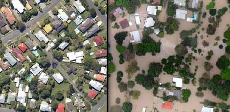
Unfortunately Brisbane and South East Queensland were hit by yet another flood in January 2013. Although not quite as destructive as the 2011 floods, many properties were affected and many people seriously concerned about the possibility of this happening again. This event illustrates changes in weather patterns and with this, the importance of protecting your land and property by getting the necessary surveys done. Here are some surveying services we provide which will assist you with the planning and development of your property.
Determining The Height Above Sea Level For Your Land
If you were not aware, when the authorities release statistics on how high the different rivers are peaking during a flood (e.g. Brisbane river to peak at 2.5 metres) this is in relation to the height above sea level. This will give you some idea of where the displaced water will end up in nearby suburbs to that river.
To ensure that you can use this data to find out whether your property may flood or not, it is necessary to know the elevation of your land above sea level. We can help provide you with a detailed report for this by doing a topographic survey of your land and the buildings contained on it. Having this information will help give you a better idea if your property is going to flood from the expected river peak levels. This is particularly important if you are planning to build or raise your house. If you are currently involved in designing a new house or you are raising a building to avoid flood waters, then now is the time to consider your land’s drainage and relation to AHD levels.
Flood Maps
This same information will also help you more accurately read the flood maps produced by the local councils. If you know how high your property sits above sea level, you can reference this when viewing the flood maps that are released to more accurately determine if you are in the firing line.
Height Certification Amended to 9.5 metres in Flood Prone Areas
Recently the Brisbane City Council increased the maximum height allowed for the roof of a residential house from 8.5 metres to 9.5 metres. This change is one of a number of changes proposed in the Draft City Plan. This applies to those areas of the city which were affected by flooded creeks or Waterways and/or the Brisbane River Flooding. This means any new buildings or extensions to previous structures now may be raised and certified to a maximum of 9.5 metres.
Flood Study Surveys
Local authorities require all development of land to be above the 1 in 100 year flood level. To determine this level, the topography of the land must be surveyed and used with the volume of the catchment to determine the Q100 level relative to the Australian Height Datum (AHD). With the current weather extremes, this is very important to consider before starting any new developments or before you purchase a new property. If you are unsure please contact us and we can help establish the Council requirements and Q100 levels applicable to your property.
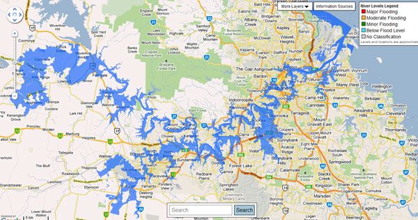
The 2013 Brisbane flood map showing prone areas
Latest news
Redland City Council Planning Scheme Changes
8th Sep 2021
Redland City Council – Medium Density Zone Code Review
23rd Aug 2021


What is town planning & why do we need it?
25th May 2020

7 reasons why you should have your property surveyed before purchasing
Choose our experienced team for your next project. Get a free quote today.
- PROUD MEMBERS OF -

![]()
East Coast Surveys (Aust) Pty. Ltd.
ABN: 69 311 277 696
BRISBANE OFFICE
7B Natasha St., Capalaba, Qld 4157
© 2022 East Coast Surveys. All Rights Reserved. Website by Imagine If Media